 "Pin It")
Walks and maps
There are hundreds of miles of footpaths throughout the Devon & Cornwall countryside, and several in every direction around Hartwell. A detailed map will be extremely useful to identify exactly where the footpaths are, and nowadays the excellent online versions will also display exactly where you are on the map at any given point. We would highly recommend subscribing to one of the smartphone apps for walkers which cover the whole of the UK with detailed Ordnance Survey maps, as well as suggesting routes you might want to take. We've tried out 3 apps and briefly reviewed them at the bottom of this page. Alternatively there are some good old fashioned paper OS maps of the local area available to borrow at the house*.
Here is just a selection of some of our favourite short walks close to the house. If you first install one of the GPS navigation apps mentioned below, then view this page on that smartphone, you can download and import the routes straight into the apps (** installation instructions below):
| Description | Length and Download link** | |
|
Catsbridge/ bluebell wood circuit. Down the road to Catsbridge, up through a pretty little wood (full of bluebells in the Spring) across a couple of fields, to the edge of Sydenham Damerel and back through some fields to Hartwell. |
About 40 minutes. |
|
|
Sydenham Damerel circuit. Starts with a couple of fields into the village, along a bridleway, then back to the house via the relatively quiet country road. |
Approx 45 mins |
|
|
Scrubtor Circuit. Across a field, down the hill through the woods, then round the road and back along a bridleway to Hartwell. (Despite the name, Scrubtor is simply a hamlet and there's no actual 'tor' that we're aware of!) Wear wellies if it's been at all wet recently as there can be big puddles! |
Takes about 50 minutes. |
|
|
Sydenham Damerel/Tuell circuit. Through to the village, along a couple of bridleways, past a tiny wood with the tallest oak and beech trees you've ever seen. From here look back down to Sydenham Damerel and Cornwall beyond. Then continue across come fields, and back along the quiet road to Hartwell. |
5.5k takes about 1hr 45. |
|
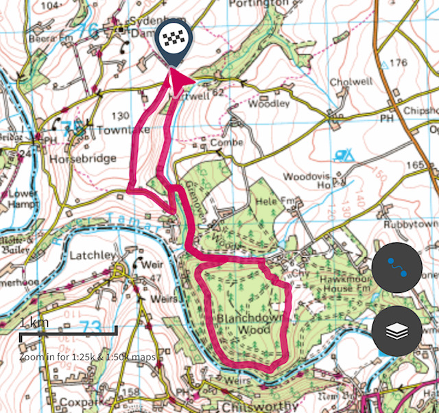
| Wheal Maria Trail. A walk down the hill and through to the pines of Blanchdown Wood, passing many old mineshafts (now safely fenced off!) You also pass the ruins of a Victorian arsenic processing plant, and see some lovely views across to Cornwall. You can shorten this walk by 3k (40 mins) by driving to the scrubtor car park on the edge of the woods and starting from there instead. |
8k (2hrs30m) if you set off from the house. Or 5.5k (1hr45m) if you start from the car park. |
* The OS paper maps which cover the Tamar Valley only (ie only our part of Devon and Cornwall) are 201 for the 1:50 scale or 108 for the more detailed 1:25 scale.
** If viewing this page on a smartphone, firstly make sure you have one of the apps mentioned below installed on your device. Then just click on one of the routes above to download it. Once downloaded, open the file and you may see a page of nonsense text - simply opt to share that page and choose the relevant installed navigation app and you should be able to open the route in that app. If this is not possible, you may need to use the desktop version of the app, download the route to that and then check that it has synced with your smartphone.
Walkers navigation Smartphone Apps
Each of the following apps allow you to view a basic un-detailed map and view your location for free, but don't display the actual footpaths. They can therefore be greatly enhanced with an Ordnance Survey subscription. As with all GPS maps they can be quite thirsty on your battery though, so do set off fully charged!
OutdoorsGPS - (iPhone /ipad only) Overall this is the simplest of the Apps to use. As with the others it allows you to follow your own prepared routes, or those created by other people (see ours above but you may have to download them via a desktop to be able to see them), and 'record' any walks you do, so you can save them for future reference. You can also plan and create your own routes via a desktop computer. OutdoorsGPS has very few features compared to the other apps, which for you might be an advantage or a disadvantage! Unfortunately, there is no monthly or trial period, so it's a subscription of approx £20 for a year's access to all OS maps in the UK. If you search "Hartwell" from within the App you'll find some of the routes we have prepared.
OSMaps - (iOS or Android) This is the App you will need if you have purchased a recent paper OS map and have a voucher code for the online GPS version of that area only. Alternatively if you just want to go digital, you can utilise their 7 day free trial period with access to OS maps for the whole UK. You can then either subscribe for £3.00 monthly, or from around £28 annually. This is now our favourite of the 3 apps mentioned here. Maps and routes can be printed off. Several of the local routes we have prepared are available by zooming into Hartwell on the map and clicking on "Find Routes."
OutdoorActive (not to be confused with OutdoorsGPS above!) (iOS or Android) - Used by serious walkers, this App has all the features mentioned above plus several others too. It has a nice clear interface and lots of suggested routes - on foot, bike, horse, or even offroad vehicle! But possibly more features than you need if you just want to follow a simple walking route from A to B. If you want a proper OS map with details such as footpaths etc you need to subscribe to 'Pro'. This has a free trial month and then £27 annually. Just remember to cancel it if you only want the trial! There's also a 'Pro+' version £54 pa which has even more features and many other types of map for much of Europe and beyond.